
If you are a photographer, you know that the technical details of a photo matter. Camera type, exposure, aperture, focal length, ISO speed, flash, resolution, and GPS location data, if available, all contribute to the…
Blog
Solving the Two Sum Problem from LeetCode using Python: A Step-by-Step Guide

I have posted a new video on my YouTube channel where I solve a coding problem from LeetCode using Python. In this video I’ll take you on a journey to solve one of the most…
GeoCapture: The Ultimate Tool for Collecting Geographic Data Anywhere, Anytime!

Hey everyone! I wanted to share with you a project I’ve been working on called GeoCapture. It’s a handy tool for anyone who needs to collect geographic data without access to professional GPS equipment. As…
Discover the Hidden Metadata in Your Digital Photos with EXIF Reader – A Versatile Python Script with Exciting Features!
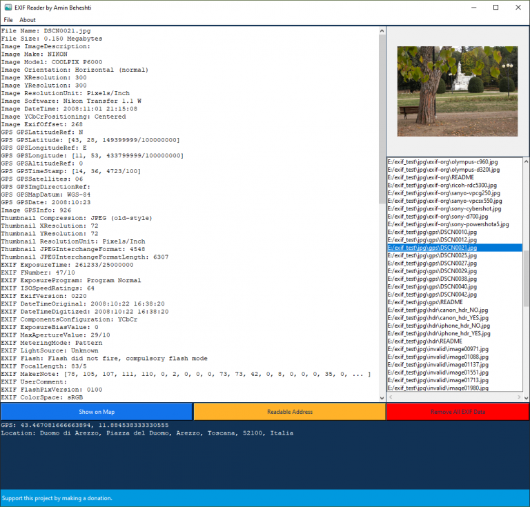
Hey there! Are you someone who loves taking digital photographs and wants to know more about the metadata stored in them? Do you want to get a glimpse of the various camera settings used to…
LeetCode Problem 121. Best Time to Buy and Sell Stock Solution in Python

In this article, we’re going to learn about a fun problem called “Best Time to Buy and Sell Stock.” This problem is all about figuring out how much money we can make by buying and selling a stock at the right times.
LeetCode Problem 1. Two Sum Solution in Python
Have you ever played a game where you have to add up two numbers to get a certain target number? Well, that’s kind of like the problem we’re going to talk about today.
Batch Geocode Coordinates to addresses in Python

A Python Script that Batch Geocodes Coordinates to Addresses using the OpenStreetMap Nominatim API
Merge Multiple Shapefiles into a Single File
This is a Python script that automates the task of merging multiple shapefiles into a single file. This can be useful if you have multiple shapefiles that represent different features or layers, and you want to combine them into a single file for easier analysis or visualization.
Batch Geocode a Large Number of Addresses Using The ArcGIS Geocoding API
Python script for batch geocoding addresses using the ArcGIS Geocoding API This script automates the process of batch geocoding a large number of addresses using the ArcGIS Geocoding API. It reads in a list of…
Word Translator

A simple word translator built with React.
HubSpot Academy Certifications

Certifications earned from HubSpot Academy
Google Certifications

Certifications earned from Google
freeCodeCamp Certifications

Certifications earned from freeCodeCamp